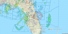
A picture is worth a thousand words… AeroMap gives you the picture you need! AeroMap answers the need of your communications center to find your scene call and find it fast. The search features allow you to search on a street address, the intersection of two streets, or any waypoint such as a preplanned LZ, town name, or landmark. Once you have found your LZ, a single click on the "Send to Flight Plan" button and the waypoint is in the flight plan! It couldn't be simpler!
Vehicle Tracking
AeroMap shows you the flight plans of all active units as lines on the map. Position reports are shown as dots. Watch your aircraft as it flies to its destination! You can easily tell if it is off-course. The last known position of the unit has a user-defined icon to mark the spot - show your helicopter as a helicopter and your ambulance as an ambulance! Click on it and vital flight plan information is displayed - coordinates, flight number, referring and receiving agencies, and the type of flight. The icon color automatically changes to reflect the unit status - Ready, Active, Out of Service, Overdue, or Weather Hold.
Satellite Tracking
Tired of following your units by hand? AeroMap connects directly to the satellite transceiver to get position reports and unit status automatically! Send two-way text messages. Never lose contact with your aircraft no matter what "hover-hole" they are in. Talk to us for more details on this exciting product and Innovative Engineering's exclusive private virtual network with major satellite transceivers.
Maps
AeroMap comes with street level mapping for your coverage area, as well as outline and county maps of the entire US. WORLD geomaps are also available! The maps will automatically display your AMS Dispatch waypoint data such as preplanned LZ's, hospitals, and landmarks! Aviation data such as navaids, Class B airspace, Restricted and Prohibited areas, etc. are also shown. Data updates are available from us so you are never out of date on this vital information.

